We Will Never Be Here Again: the amazing story of Svein Tuft, the greatest Canadian cyclist few have ever heard of…

The tattoo found on Svein Tuft’s right forearm.

Svein Tuft during the Individual Time Trial, 2008 Beijing Olympic Games, China.

At thirty-two years of age, a virtual lifetime late compared to his competition, Svein Tuft is poised for greatness on the cycling world stage. Late? Perhaps. But then again, Tuft has always marched to the beat of a different drummer, with a sense of timing that is decidedly his own. Following up on unorthodox early career preparations that included bicycle touring to Alaska and Mexico, as well as boxcar hopping along the railway lines of western Canada, Svein Tuft has come off a breakout 2008 season. After finishing seventh at the Beijing Olympics and an even more impressive second at the world championships, Tuft’s fortunes are on the rise and his best results appear yet to come. More importantly, it looks like they will come on his terms. In a sport that has been dealing with the demons of rampant drug use amongst its elite, threatening to destroy it from within, Svein has found a pro team whose values mirror his own – developing young riders and promoting ethical sportsmanship by riding drug free.

“We will never be here again” is the tattoo emblazoned on Tuft’s right forearm, staring at him whenever he rides his bike. The “we” could perhaps just as easily have been an “I”, and this is significant. At a time when much in society seems focused on the “I”, win at all costs mentality, Svein Tuft represents an individual who has always embraced the greater collective good, drawn to the sport of cycling for the “we”: the team camaraderie, the opportunity to promote and provide support to younger athletes, and the desire to strive for the success of the team and teammates around him, often at the expense of his own individual goals.

Set amongst incredible European scenery, as well as the colour and pageantry of its cycling crazy hoards, Svein Tuft’s story will now move to the sport’s pinnacle, top tier professional racing. In Europe, where the sport’s elite are afforded rock star status, Tuft and his team will prepare in some of the sport’s preliminary classics, and hopefully culminate in what is arguably cycling’s crown jewel, the Tour de France. He will compete against the celebrity of Lance Armstrong, and other premier talents. But, he will also be immersed in the seemingly relentless bout the sport continues to fight against the stigma of performance enhancing drugs.

BACKGROUND

Back in 2003, Svein Tuft turned his back on the sport he loved due to the prevalence of performance enhancing drugs and the pressure to use them. But, re-energized and fresh off a year of cutting lawns, wrestling, hiking and back-country skiing, Tuft was lured back, working hard with the Langley, B.C. based Symmetrics Cycling Team over the next four years. He pushed himself to see how much, in his words, he “wanted to hurt.” And, with the support of this local team that espoused and raced with his values, he did it clean, living by the “Cheaters Suck” motto emblazoned on his socks.

In 2004, Svein Tuft would quietly go about winning the first of what would become four Canadian national titles in the individual time trial. Then, in 2007, his fame would spread south of the border when on a day that began in a virtual blizzard, he would dismantle the field on national television while winning the inaugural U.S. Open Championship road race, prompting on-air colour commentary person and former pro racer Frankie Andreau to label the unshaven Tuft: “Grizzly Adams from the Great White North.”

Tuft at the 2007 U.S. Open Championship road race wearing Symmetrics colours, Richmond, Virginia. Photo © Kevin Field.

In 2008, Tuft’s winning run included four gold medals at the Pan Am Championships, impressive stage race victories in Canada and Cuba, and the overall points championship for the North American pro racing series. At the Beijing Olympics, he stunned the cycling world by finishing seventh in the individual time trial. Even more astounding was that he was in line for a medal up until the last dozen or so competitors. Svein had arrived on the international cycling scene. But, Tuft wasn’t done. The month of October saw him in Varese, Italy at the World Championships and a result that had the European and world cycling press aghast and asking – “Who is this Svein Tuft?” They would have an answer shortly.

2008 World Cycling Championships, Individual Time Trial, Varese, Italy. Photo © Sirotti – cyclingfans.com.

Transcript taken from the Cycling Weekly text update of the 2008 World Time Trial Championship from Varese, Italy:

13.47pm: Canada’s Svein Tuft, the revelation of the Olympic Games time trial, where he was seventh, is going well, with the best time at the first check point at the moment.

14.06pm: Svein Tuft of Canada is flying. He is 41 seconds quicker than Brajkovic at the third check point. According to his Symmetrics team website, one of his hobbies is freestyle wrestling. (We’re not making this up).

 Photo © Bryn Lennon / Getty Images.

14.20pm NEW BEST TIME: That’s the ride of the day so far by Canada’s Svein Tuft, who has wiped the floor with Devolder’s time to top the leaderboard. 52-44, first man under 53 minutes.14.24pm: Tuft apparently had a mechanical problem and had to swap bikes between the third checkpoint and the finish. How much has that cost him? It could be the difference between winning a medal and not.

Amazingly, Tuft would win the silver medal, finishing only 43 seconds back of the eventual race winner after getting a flat in the final 6 km. The press was incredulous that a virtual unknown had accomplished what he did, flat tire and all!

Svein Tuft, silver medalist, 2008 World Cycling Championships, Individual Time Trial, Varese, Italy. Photo © Sirotti – cyclingfans.com.

THE PAST

So, where does one really begin when telling the story, or perhaps more accurately, the legend that is becoming Canada’s Svein Tuft? We could start with the fact that he quit school at age 17 and embarked on the cycling version of a walk-about. With a virtual garage sale bicycle and after constructing a small utility trailer to tow behind it, Svein set off from Langley, B.C. on a little tour…to Bella Coola. His cargo was a simple one-person bivy shelter, a blanket, a camp stove and oh yes, his 85 lb. Alaskan Malamute dog named Bear. Did we mention that Bella Coola is 1000 km from Langley and Svein, due to a lack of funds, was eventually forced to cook over open fires with nothing but a sack of potatoes for sustenance?

Tuft and his dog Bear. Who could foresee where this was all heading? Photo © The Holness Family.

We could talk about how he roamed the west coast on a bicycle from Mexico to Alaska for five years. Or, we could talk about the fact he rode the rails across western Canada as a boxcar-hopping vagabond, resembling more a product of the dirty thirties rather than the 1990’s. Of course, we could talk about how he would enter some local cycling races on a whim, even lead his first-ever competitive race on sub-standard equipment and wearing street clothes before a flat tire would force him to withdraw. And, we could eventually talk about how, two races later, Svein would taste victory. Within two years he would make the Canadian national team and the rest, as they say, is history.

But, we couldn’t forget about how Tuft, recognized as an emerging talent, was invited down to the Mercury cycling team’s training camp in San Diego, California. Accepting the invitation, he would head to Southern California – not by plane, train or car, but, in what would be typical Svein Tuft fashion, by bicycle.

THE PRESENT

As the 2009 cycling season begins we find Svein racing for one of the world’s top professional teams, U.S. based Garmin Slipstream. With a mandate to clean up the sport both from a drug testing and race results perspective, the team has managed to coax the reluctant diamond in the rough superstar away from the cozy confines of his local Symmetrics team family. Garmin Slipstream team director Jonathan Vaughters, a former teammate, has been pursuing Svein for a number of years and sees him as an important cog in the multi-million dollar team’s success in Europe and the sport’s marquee grand tours, the Giro d’Italia and the Tour de France, where he will be competing against cycling’s elite, including a returning Lance Armstrong.

Fresh off international success and totally dedicated to cycling as a profession for perhaps the first time in his career, many feel Tuft, at the ripe old age of 32, still has his most impressive results ahead of him.  And, if that is the case, it will sit just fine with new team director Vaughters: “I remember in 2003 I thought, ‘If this guy ever gets serious and loses that spare tire, he’s going to fly.’ “

It seems as if Svein Tuft is poised to fulfill that prophecy, all while maintaining his own unique philosophy. So, let’s hang on for the ride as this unorthodox world-class athlete strives for success in a wonderful, and particularly relevant place and time; a place and time where we, like Svein Tuft, will never be again.

Svein Tuft at the start of the 2008 World Individual Time Trial Championship, Varese, Italy.

ASIDES

“I didn’t want to say anything about it before the race, but Svein was always our guy,” said White. “The ethos of this team is you get what you give. Svein has been part of all our great time trial results, and I think it’s only fitting that the guy who’s been the lynch pin of so many big moments gets the limelight for at least one day.”

Orica-Greenedge Sport Director Matt White after team wins 2014 Giro d’Italia TTT, placing Svein Tuft in 1st place overall, May 9, 2014


“Svein is very, very versatile,” White said. “I’ve taken him to the Giro, and the Vuelta, and it’s great to see him making his Tour debut at this age. You pick a team for the team’s goals, and we didn’t come here to specialize in the team time trial. What we want to use him for, specifically, is to move the train up in the closing kilometers. He does a great job of that. He can ride at the front, for a long time, at 55 kph. He’s not part of the leadout, but he’s a crucial member in positioning Brett (Lancaster), Daryl (Impey) and (Matt) Goss in the final.”

Tuft has also proven to be a dependable workhorse, valuable in defending the team’s overall race lead by setting tempo on the front, keeping breakaways in check. It’s something Tuft says he enjoys.

“I’m fine with that,” he said. “There’s stress in the first part of the stage, but at the end of the day you’re just riding on the front, ticking away the kilometers. That’s enjoyable for me.”

In fact, in many ways, Tuft is, as the saying goes, just happy to be here, at this 100th Tour de France, as the oldest rookie of the modern era.

VeloNews.com, July 5, 2013


“Ride of the day…No, make that ride of the millennium goes to GreenEdge’s Svein Tuft. 200km ALONE controlling the peloton! Respect.”

Tweeted by fellow competitor,and world champion Mark Cavendish after stage 2, 2012 Tirreno-Adriatico

 
Now he’s in a restaurant with big-screen TVs and a wine list doing an interview.

“I struggle with that because I never feel in place in these kinds of environments,” Tuft said. “I never have. Even with bike racing in general, I don’t feel like I’m part of it.”

Garmin-Slipstream is making him part of it. Underneath his seemingly perpetual two-day grizzle and Paul Bunyan lifestyle lies one of the most talented bike racers in the world.

Team director Jonathan Vaughters, his teammate six years ago on a continental club called Prime Alliance, signed him in September and is trying to tap this raw commodity, like a baseball scout who finds a can’t-miss shortstop in a remote Dominican village.

The Denver Post, February 27, 2009


“All of those wonderful adventurous stories of riding his bike to Alaska, the railroad-car jumping, yes, those are all true,” his mother said.

“But I want everybody to know that, no, Svein was not an orphan. He was raised by two loving parents. He had his own room, a trampoline, a motor scooter. But he was just looking for something else.”

The New York Times, Saturday February 7, 2009


2014  HIGHLIGHTS

  • 1st Giro d’Italia, stage 1 TTT, wears the maglia rosa (pink jersey) as overall race leader
  • 2nd Tirreno-Adriatico, TTT

CAREER HIGHLIGHTS

  • 1st Tour de San Luis, stage 4 ITT (2013)
  • 1st Tour de Slovénie, stage 1 ITT (2013)
  • 1st Tour de France, stage 4 TTT (2013)
  • 1st Duo Normand (2013)
  • 1st Canadian National Time Trial Championships (2004-2006, 2008-2012)
  • 1st Tirreno-Adriatico, stage 1 TTT (2012)
  • 1st Tour de Beauce, stage 4 ITT (2012)
  • 1st Eneco Tour, stage 2 TTT (2012)
  • 1st Eneco Tour, stage 6 ITT (2012)
  • 1st Duo Normand (2012)
  • 1st GP Stad Zottegem (2011)
  • 1st Canadian National Road Championships (2011)
  • 1st Tour de Beauce, stages 4 & 6 (2011)
  • 1st Eneco Tour, prologue (2010)
  • 1st Post Danmark Rundt, stage 5 (2010)
  • 1st Tour de Beauce, overall (2008)
  • 1st Tour de Beauce, stage 4a (2008)
  • 1st Pan-American Championships, ITT, track: individual pursuit, madison, and points race (2008)
  • 1st UCI Americas Tour Championships, overall (2007)
  • 1st US Open Cycling Championships (2007)
  • 1st Vuelta a Cuba, overall (2007)
  • 1st Vuelta a Cuba, stage 11 ITT (2007)
  • 1st Canadian National Track Championships, individual pursuit & team pursuit (2006)
  • 2nd Road World Championships, TTT (2013)
  • 2nd Road World Championships, ITT (2008)
  • 3rd Road World Championships, TTT (2012)
  • 3rd Tour of Missouri, overall (2008)
  • 3rd Three Days of De Panne, stage 3 ITT (2012)
  • 4th Tirreno-Adriatico, stage 7 ITT (2012)
  • 4th Three Days of De Panne, overall (2012)
  • 4th Tour de Beauce, overall (2012)
  • 5th  Circuit Cycliste Sarthe – Pays de la Loire, stage 3 ITT
  • 6th Tour de France, stage 11 ITT (2013)
  • 7th Beijing Olympic Games, ITT (2008)
  • 169th “Lanterne rouge”, Tour de France overall (2013)

To be continued…

Svein Tuft interview July 16, 2017
Posted in Sport | Tagged , , , , , , , , , , | 4 Comments

A Thin Red Line: Expecting the Unexpected While Bicycling India’s Malabar Coast.

Communal washing ghat in rural Maharashtra, India. Photo © Mark Mauchline.

The driver’s eyes were the size of saucers as the local bus came charging down the pavement towards me, its sloppy steering mechanism barely able to keep it on the road, let alone on its side of the imaginary center line. The wild-eyed man threw his steering wheel back and forth with a force and energy that seemed entirely disproportionate to the zero effect it had on his aged behemoth’s front wheels. It passed me in a cloud of thick exhaust, probably headed home, close to where we had both begun our day.

The day wore on with the rhythm of a metronome as I passed trees chattering with their monkey tenants and roadside stone tablets religiously marking their five kilometer increments. Eventually, the grade began a downward trend through increasingly lush surroundings. After rounding a final curve at the base of the ravined descent, it passed a handful of houses and with neither a glance nor pause the road, like it so often did along Maharashtra State’s coast, slid seamlessly and silently into the murky estuary and disappeared.

Roadways regularly came to abrupt, water-inspired ends in this part of the subcontinent, necessitating the need for a ferry, or some sort of boat in order to continue on one’s journey, be it on foot or otherwise. The boat, or kishti as it is known in Hindi, was often motorized and able to carry a dozen people, livestock, bicycles and even motorcycles. It was left up to the ingenuity and creativity of the operator as to how everything fit in and in typical South Asian style, the boat’s departure schedule was based on when it was full, something I came to refer to as critical mass.

On more than one occasion I was forced to wait for the better part of an hour before being allowed to wheel my steed across a narrow wooden plank, carefully squeezing myself and my two-wheeled partner amongst the men, women, children, goats and chickens whom had boarded before me. It seemed as if my seat row number was always the last to be called. Eventually, we would begin our crossing as I desperately tried to keep my bicycle’s chain from eating the flowing fabric of women’s’ saris around me, balancing it precariously against the vessel’s gunwales as we ploughed towards distant landings across the way.

Coastal water taxi, Kerala, India. Photo © Mark Mauchline.

But, there were also instances where the boat was no more than a simple dugout canoe, and in only the odd instance, thankfully, there would be neither boat nor person in sight. At those times, I would be forced to judge the depth of the water, gauge whether the tide was incoming or outgoing, and carefully wade my bike and gear over in successive trips. This was one of those times.

The red line following the western coast of India was of the thin variety, rather than the bold. But, it was red, as opposed to the vague black lines that seemed to predominate in the road atlas of India I had been scouring for months while planning this trip. In my mind, that was sure to count for something. So, it was with this small bit of reassurance and a healthy dose of naievity that I planned my bicycling journey from Mumbai, the former Bombay, to the subcontinent’s southern tip at Kanyakumari.

People are attracted to destinations for myriad different reasons. I am a name person and a name person in the most romantic sense. So, since my first sighting of the italicized name Malabar Coast snaking along India’s contours in National Geographic’s World Atlas, it has been on my bicycle touring must-do list.

Bombay's financial district, Mumbai, India. Photo © Mark Mauchline.

My trip began in Mumbai, the country’s largest metropolis which balances precariously on a peninsula of re-claimed land. It was the commercial and entertainment center of the country as well as having the dubious honour of housing some of Asia’s largest slums. A bouillabaisse of humanity, it represented the hopes and dreams of a nation, as well as its in-your-face reality. At the time, India’s population was rapidly approaching one billion and over half of its citizens were under thirty years of age. Having the energy and zeal of youth and a sizeable, well-educated portion of its population, India was already the future to large corporations looking to outsource to a well-trained, more cost-effective workforce.

To me, it was the land of my mother’s birth and with relatives still calling it home, it represented an exotic and intoxicating past. Over a quarter of a century earlier, it was also the place where, in the city of Jabalpur, I learned to ride a bicycle. The result was a magnetism and interest towards her that was perhaps only matched by the interest shown in me by the outstretched palms of the destitute and less fortunate. As a westerner, at any given time I felt as if I was the focus of hundreds of pairs of curious, staring eyes.

A ferry from the Gateway of India, the ceremonial Victorian era jumping off point for British colonial rulers, to the small jetty in the sleepy end-of-the-road town of Mandwa took only an hour. Although close to the mainland, it was light years from the hustle and bustle of the seemingly bursting at the seams Mumbai. Traffic was light and the road was in relatively good shape as I pedalled through a string of towns and villages on my way to Murud-Janjira.

Portuguese colonial fort, Murud Janjira, Maharashtra, India. Photo © Mark Mauchline.

Murud was a decent size town whose claim to fame was the stoic Portuguese fort lying just offshore. It was Ramadan and the predominantly Muslim residents of the region followed the daily fasting schedule with the lunar equivalent of a tide chart furnished by the local newspaper. The entire Muslim population, save for the young, very old, or pregnant women, refrained from both food and drink from sunrise to sunset. Then, a virtual mini celebration would erupt just after the sunset call to prayer. A flurry of activity would result as locals prepared food for the official breaking of the day’s fast, a sort of ritualistic appetizer that was the starter’s pistol for the much-anticipated gastronomic free-for-all to come.

As a visitor, I was invited to break the fast with many of the people I had met. Abstaining from both food and drink was obviously difficult, seeing as the average temperature was in the mid 30’s Celsius, and the majority of people were involved in some sort of manual labour for work. But, even with this hardship, I was envious of the social side of Ramadan. Every night was an opportunity to share the breaking of the fast with friends, family, and as was the case with myself, complete strangers. It was like my Christmas, only a month-long.

Leaving Murud gave me my first taste of the inaccuracy of government sanctioned tourist literature. In this instance, they were promoting a new hotel on a particularly beautiful and pristine stretch of coast. After pushing on late into the day in order to reach the town of Velneshwar, I soon realized that there was zero accommodation to be had, and the aforementioned tourist resort was, at best, years away from completion. The pamphlet promoting the resort was already one year old and as of yet, the ground hadn’t even been broken.

As would often be the case on my journey, this seemingly frustrating situation led to a wonderful experience with locals that might not otherwise have been possible. A neighbourhood shopkeeper and his family opened their entire home to me even though I was simply wanting to camp on their property. The following morning was nothing less than intoxicating. As I sipped chai in the filtered sunlight of their small coconut grove, the sound of waves slalomed through the gently arced palm trunks while the ever pervasive smell of the sea was being subtly diluted, sweetened by the essence of cardamom wafting upwards from my cup.

Children after school, somewhere along the coast road, Maharashtra, India. Photo © Mark Mauchline.

Such was the adventure of manoeuvring along the Konkan Coast, the lush coastal region sandwiched between Maharashtra’s Deccan Plateau and the Arabian Sea. I would see only a few vehicles each day. The usual routine was to begin a slow gradual climb from the inlet I had just crossed until the road levelled out. Eventually, the quiet pavement would begin its regular descent towards a small town, another inlet and boat crossing, or both. Often, the first sign of human habitation was a beautiful white-washed building with amazing hand-painted billboards for Pepsi or Indian brands like Thumbs Up. The cycling contained enough variety and challenge to help the day fly by, and there was enough bottled water and soft drinks available at regular intervals to quench my thirst.

One day, after rounding a headland and pedalling and pushing through loose dirt for the better part of an hour, the road degenerated into a wide path lined with white baseball-size rocks. A short distance later, the rocks ended on what seemed to be a high lookout over a beautiful, tranquil estuary the colour of weak tea.

“So, where to now?” I asked myself. As I stood there stumped and confused, I decided to munch on one of the delicious, finger-size bananas that I had purchased in the previous town. A small group of women walked by, balancing their goods assuredly on their heads. They passed by me with indifference and began to descend the rocky headland on what seemed to be an obvious, if invisible to my untrained eye, trail. About the same time, a dhow-like sailboat came into view and waited for them to wade out and board.

Choking down my last bite, I launched my loaded bicycle down to the water’s edge, waving futilely at the now departing boat. It continued across the small estuary to the beach on the far side and unloaded its passengers before, thankfully, returning for its next load, me.

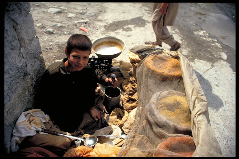
After removing my panniers and bags, I waded out with my now incredibly light steed over my head. One of the smiling crew followed me on the return trip to help me with the rest of my gear. They took me to the same beach where the women disembarked and as I smiled and embarrassingly mumbled my thanks, I held out a small wad of tattered rupee notes and left my travel budget in the hands of the gods. So worn were some of the notes that they resembled scraps of parchment with torn, corner-less edges and a translucence that must have been the result of decades of finger-oiled transactions. Some were so dark in colour that they were illegible, at least to me. Ten rupees seemed to be the usual rate for a bike and rider. At about twenty-five cents, it was a bargain.

Confirming directions was always a good idea, but not always easy in rural India. Hindi and English, although both official languages nationally, were often of little help when the lingua franca was one of the many semi-official state languages such as Marathi in Maharashtra, or Kaanada in Karnataka.

Maps, although useful, could not be relied upon. They often showed roads where no roads existed and, just as often, abandoned me to dead ends and unexpected river crossings where roads had been clearly shown. It seemed as if even the government hadn’t a clue as to where the “coast road” actually went. All of the tourist pamphlets and information offered by the state-run tourism offices were purposely vague when it came to useful logistics and directions for travel down the sun-drenched ribbon of land they were actively promoting as the “next big thing”.

Shopkeepers could sometimes provide help. Pointing in the direction I was travelling, I would attempt the name of what I understood to be the next big town, making sure to include a questioning inflection on the end. It was a simple but effective way of staying on course. Though, more often than not, my query was met with what I labelled the head “waggle”. It was about as non-committal and frustrating as you can imagine when one is looking for absolutes and confirmation. Neither an affirmative up and down nod, nor a dismissive side to side shake, it was the confusing, rolling, head-tilting swell that was part “yes”, part “no” and mostly, “if you say so.” Welcome to India.

As it turned out, the most reliable source of help on the road came from the medical clinics I would pass in many towns. Most, if not all doctors and nurses received their education in English. So, even if they were directionally challenged, I could at least stop and proceed to question them in more detail about the road up ahead. I would ask them to write down the names of any upcoming towns in the local language, allowing me to recognize them on the road signs I might encounter, all of which would be completely devoid of English.

Maharashtra coast, India. Photo © Mark Mauchline.

Of course, the only definitive confirmation occurred when I could see the sea over my right shoulder. Then, and only then, was I absolutely sure of my southerly direction. When the road ventured inland and the coast was out of sight, I would rely on my compass if for no other reason than to make sure I wasn’t heading in the absolute wrong direction. Some intersections, mainly due to the number of available options, proved to be a calculated risk with the resulting extra distance pedalled chalked up to experience.

The days flew by as I rode past vast empty beaches, through bustling district centers the likes of Ratnagiri and Malwan, and alongside further forts such as Vijayadurg and Sindhudurg. Then, just as I had gotten used to the up and down nature of the Konkan Coast, as well as its regular nautical interludes, a much larger vehicle ferry took me to a fort named Terekhol and the state of Goa.

Mother and daughter sorting the catch, Goa, India. Photo © Mark Mauchline.

Goa was a land of hedonistic pursuits, claustrophobic weekly flea markets and a repository for travellers who ran the gamut from hippie to yuppie and everything in between. Virtually all side roads headed toward the beach, lined with enough accommodation and dining options to satisfy any taste. Fish and seafood were on every menu, and so it should have been. It was fresh, caught overnight and brought ashore by the local fisher folk early each morning while the travelling throngs slept off the previous night’s festivities.

As it turned out, the most amazing cycling, and an unexpected surprise, proved to be along Goa’s true coast road – the beaches themselves. Both north and south of the colonial inspired capital Panaji, I was able to bicycle for many kilometers along the hard, compacted and ever shifting swath of sand that danced between the waterline and the deeper, looser, un-bikable area up near the dune grasses. Eventually, a river or rocky headland would force me inland and onto a southerly inspired secondary road. In this way, except for in and around Panaji, I was able to avoid the congestion and characterless persona of National Highway 17.

Fruit? Benaulim Beach, Goa, India. Photo © Mark Mauchline.

Finally, after the better part of a week, I bid adieu to the Christian-infused architecture of Old Goa, as well as the sparkling white necklace of beaches named Anjuna, Calangute, Colva and Benaulim. It was with mixed feelings that I continued south towards the next Indian state, Karnataka.

Re-joining the highway just north of the state border, it was late in the day with traffic predictably light. Here, I would meet the only example of in your face police presence along my entire journey. Actually, he was a soldier and sat on a simple, steel folding chair on the road’s shoulder, next to a raised bar that must have served as a barricade or road block when lowered. He was so unassuming that I almost missed seeing him.

As I flew by his makeshift post he whistled me back. Turning around more out of curiosity than obligation, I couldn’t help but wonder where his guard-house or office had gone? As far as I could tell, we were kilometers from anywhere and there was no sign of an official looking building, a vehicle, or even a table to be seen. I couldn’t help but wonder, “Where did he eat his lunch?”

Pushing myself towards him, I offered my usual namaste and was met with a quizzical, outwardly stretched arm with an upwardly facing palm and a flick of the head, which might have been him sniffing the air. But, in this case, I interpreted it as, “Where are you heading?”

Surveying the situation a little further, I spotted the soldier’s companion, a vintage firearm that was more musket than rifle. It was old, British, and probably an Enfield. Sitting lazily between the guard’s legs, it pointed upwards but safely out to sea. It soon became obvious that he did not speak a word of English. So, after the requisite attempt at conversation, and the resultant head waggle response, I decided to secure my release by flashing my credentials.

I had been carrying my retired uncle’s business card throughout my trip. Yes, my Indian uncle, born and raised, was long since retired. But, the list of positions and appointments on his card were impressive: vice-chancellor of this, director of that, Indira Gandhi’s commissioner on such-and such, and member of so-and-so’s board. I had kept it in case I met with any bureaucratic red tape and this was the time I chose to play my trump card.

Emphasizing my Indian lineage I held out my get out of jail free card, turning it over so the local authority could survey the extensive list of my relative’s accomplishments. He tried to get a closer look as I pointed with authority to every entry, reading them aloud and with gusto, albeit in English. Then, I deftly returned it to my travel pouch and with the timing and speed of a want-to-be border runner I bolted, comforted in the fact that he had no vehicle and, if he possessed a bicycle hidden somewhere, I would still leave him and his ancient British Raleigh in my multi-speed, derailleur-enhanced dust. I cringed, half expecting a volley of turn-of-the-century buckshot to rain down on me during my escape. Eventually, his calls faded into the humid air as I headed toward Karwar, the first town of any significant size in Karnataka.

Karnataka was the state I knew least about. Initially, I looked upon it only as the four-day stretch linking Goa and Kerala, my ultimate destination. As it turned out, it was a pleasant ride along an undeveloped coast, through manageable urban centers like Bhatkal and Coondapoor, and included some newly built tourist lodging. These were often just comfortably cool canvas tents with cot beds and, believe it or not, electric fans.

Three quarters of the way through the state and a half day still from the town of Udipi, the river Sita lackadaisically coasted down toward the Arabian Sea. It didn’t quite reach it, preferring instead to parallel the road, turning it into a causeway between the resulting tamarind-coloured lagoon, and the turquoise blue iridescence of the ocean. I stopped early, intent on spending the night at the Turtle Bay Tent Resort.

Royal Enfield motorcycles, Karnataka coast, India. Photo © Mark Mauchline.

It was a Sunday and I shared the shaded, open air restaurant with a group of university students from MIT. They were engineers, naturally. What else would one expect from the Manipal Institute of Technology? Albeit, not as familiar to me as the American center of learning which shared the same acronym, MIT students were some of the brightest minds in south India and they often headed down to the coast for a well-deserved break.

Ironically, Enfields also accompanied these three young men. But unlike the one held by the border guard I left back in Goa, these British Enfields were of the riding, rather than the firing variety. Polished and babied the way only motorcycles of great distinction would be, these Indian Harley-Davidsons were a source of great pride for their young owners. A stunning combination of timeless styling and impressively throaty sound effects, they were also, unfortunately, a prime example of classic English electrical and mechanical unreliability. But today, standing at attention, waxed and gleaming in the shade of the resort’s dirt parking area, the vintage stable mates were nothing short of magnificent.

Back on the road, the quiet lazy coast I had come to take for granted came to an abrupt, bumper to bumper end as I approached the city of Mangalore. The city itself was downhill and off the main highway. But, at this moment, I was part of a diesel-belching logjam that was going nowhere fast and seemed to stretch as far as my eye could see.

Remnants of an earlier age, timeless Chinese fishing nets, the Backwaters, Kerala, India. Photo © Mark Mauchline.

God’s Own Country. This was the sales pitch trumpeted by the Kerala Tourism Development Corporation, as well as the slogan that represented my ultimate destination and a Shangri-La of sorts. It was an exotic land of lush greenery, a decidedly entrepreneurial population and an inviting, although slightly oxymoronic mix of forward thinking and laid back attitude. A land squeezed between the mountainous Western Ghats and the Arabian Sea, it was home to the western world’s first freely elected communist government, a meandering intra-coastal waterway known as the Backwaters, the highest literacy rate in India and, unfortunately for me, the place where the “coast road” and busy National Highway 17 became one and the same.

The bicycling was anything but relaxing. I jockeyed for position with a constant stream of traffic, which included bicycles, scooters, livestock, pedestrians, motorcycles, three-wheeled motorized rickshaws, ramshackle buses, and of course, countless trucks with the same instructions painted on their rear panels, “Honk Please.” How appropriate, I thought.

The sound of horns was nothing new to me, having cycled in South and Southeast Asia previously. Here in Kerala, the traffic was constant and the incessant bleating of horns, a bouillabaisse of differing tones and pitch, became nothing more than background noise; a constant din with the peaceful solitude of Maharashtra and more recently Karnataka but a faded memory, slipping away faster than a fresh-squeezed lime soda on a sweltering afternoon.

Days in congestion left me exhausted, more than a little agitated and covered in a day’s worth of sweat, dust and road grime. Such was also the fate of the beautiful flowering Bougainvillea that highlighted homes and businesses along much of my journey. The once effervescent shades of crimson, tangerine and fuchsia were now all wearing a jacket of traffic inspired filth.

On some days my clothes were literally black, forcing me to begin my bucket shower routine fully clothed. I would fill the bucket with slightly hot water and drench myself with the supplied cup. After this soak cycle, I would remove my clothes, push them to the side and proceed to scour the day’s dirt from my body. Once done, feeling clean and refreshed, I would pour a small single use packet of laundry soap into the remaining water in the bucket, lather it up with more hot water, then proceed to scrub and wring my clothes clean.

Successive days of this routine began to take their toll on me. Then, just when I was ready to pack in the cycling and throw myself and my beat up steed on the first train destined for a quiet, relaxing beach, the unexpected happened – a state holiday! The roads were eerily quiet, and the majority of shops and businesses were soundly sleeping and would remain so for the rest of the day. Taking advantage of the welcomed solitude, I spun my way with renewed vigor and energy to Kochi and its satellite Ernakulam, also known by its old name Cochin, the largest city I had seen since leaving Mumbai weeks earlier.

Coconuts drying along the roadside, Kerala, India. Photo © Mark Mauchline.

The morning I left Ernakulam dawned sunny and warm. But, departing town meant that I was stuck in the morning commuter traffic heading into neighbouring Kochi. It was here that I had my first and only traffic accident. I was side-swiped by a bus. Yes, the clapped out diesel-belching Tatas that had been my daily, although fleeting companions up to this point had turned on me.

Side-swiped might not be the best description. I was, to put it more accurately, side-rubbed. We were both stopped, waiting with the rest of the morning traffic to cross the causeway that led to the turnoff for both Kochi and the coast road. Side by side, we were the way you might expect two friends of sorts to be. Then, without warning, the bus driver pulled away, his ineffectual steering pointing him on a collision course with my panniers, handlebars and the right side of my body. The subsequent rubbing against me of his peeling, painted sides was not unlike an elephant exfoliating its leathery hind against a convenient tree.

My indignant yells finally drew the attention of the already stressed driver, as well as the passengers on my side of the bus. He looked at me nervously while absorbing a phalanx of verbal condemnation from his passengers on my behalf. Perhaps aware of how close he had come to shaving my legs, he slammed his beast into second and rattled off. I was left to contemplate not only the red paint souvenir left behind on my handlebars and packs, but his requisite and decidedly apologetic version of the head waggle.

Shortly thereafter, I left most of the traffic behind as I headed south towards Allappuzha and the official jumping off point for the Backwaters. It was a fast ride over a flat and relatively quiet road, at least by Keralan standards. Even though I only passed through one town of any size, the scene was decidedly urban. A steady stream of buildings flew by, consisting of homes, shops and lumber mills with their Asiatic elephant workforce putting in a hard day of stacking timber. I pedalled along to the rhythm of the work day and rolled into Alappuzha, officially dubbed the “Venice of the East” by Indian tourism officials, by early afternoon.

The canals of Allepey, Kerala, India. Photo © Mark Mauchline.

It was a lazy, hazy day with the main street straddling an olive green, water hyacinth-choked canal. The air was as thick and heavy as the waterway and marine vegetation. The Kerala Tourism Development Corporation Hotel was a multi-story building complete with a rooftop restaurant commanding a sweeping view of the street below. A great place to imbibe in a few well-deserved Kingfisher beers, it was also a perfect spot to succumb to the sporting event of the season with the locals – the World Cup of Cricket was broadcast live. My hotel was also strategically placed across the street from the ticket office for passenger boats shuttling to Kollam via the Backwaters; the brackish, slow-moving system of waterways that joined countless communities in the area. The medians of this multi-lane aquatic highway were thin fingers of land, some no wider than a few feet, buoyantly maintaining homes, schools, shops, temples, churches, garden plots, chickens, livestock and coconut groves.

The boat cruise distinguished itself as a relaxing way to cover the distance done in a full day of cycling while exerting no more energy than that required to get up and move to another seat with a different view. The vessel was long and narrow, a larger Indian version of the African Queen with a covered passenger compartment composed of hard, inward-facing bench seating. The preferred seats, business-class if you will, although exposed to the burning sun, were the plastic lawn chairs up top with their unobstructed, three-hundred and sixty degree view.

During our voyage on the following day, children raced along the adjacent shore as my fellow passengers and I resigned ourselves to drinking copious amounts of bottled water to stave off heat stroke. We motored through dilapidated, rusted-out locks where the water passed through gaping holes in seen-better-days gates. The end of our long parched day brought us into Kollam and as the sun set, my bicycle and I searched for our nightly lodging.

The next morning saw me back in the saddle and persuaded to follow a hand-painted sign onto a nondescript secondary road that took me off the main highway toward Varkala. Varkala turned out to be an embryonic resort that, at the time, was still under the radar of most independent travellers looking for the next undiscovered beach destination. The writing was already on the wall. A smattering of budget accommodations surrounded the rice paddies, with an unfortunate disregard for both planning and sewage disposal. But, there was a string of open-air restaurants perched atop a cliff overlooking a strand of pristine beach, and even a small luxury resort with an all you can eat buffet.

Looking north from Varkala, Kerala, India. Photo © Mark Mauchline.

Here, the days disappeared as I cycled through the coconut plantations, ate lazy all-day breakfasts while overlooking the sea, and explored the beautiful palm-fringed coastline to the north with its fishing community and quizzically protruding mosque spires. It was a time of introspection, allowing me to fully appreciate the land I had pedalled through, the sea which had such a profound influence on that land and, most importantly, the people who made the other two items all the more relevant.

Eventually, I left Varkala, cycling through Trivandrum and on to the beach town of Kovalam which, if it were a movie, would have been called “Goa: the sequel”. A day’s ride later I would be in Kanyakumari, the official meeting of the waters where the Arabian Sea and the Bay of Bengal flowed into the Indian Ocean at the Gulf of Mannar. South of this point, Cape Comorin, lay the island nation of Sri Lanka. Needless to say, the long-anticipated end of the road at India’s southern tip was somewhat anti-climactic. It was just that, the end of the road. There were tourists, both Indian and foreign, scooping up souvenir sand and venturing out to the Hindu temple. Others were content to take in the view with a long drawn out breath, as if looking off the end of the world.

Looking back, Varkala seemed the more fitting end for me. The Hindu village with its small lake-sized bathing ghat, flanked by a gorgeous coast and bordered by an equally picturesque Muslim enclave to its north was, like the entire Malabar Coast, more than the sum of its parts.

It was India’s west coast in microcosm and encapsulated my journey perfectly: alternately Hindu and Muslim, with a dash of differing humanities for taste. Blessed with a forward thinking population, it still danced with an earlier time. Having enjoyed the trade and communications benefits of location in the past, it was now feverishly preparing its place in the future. An aromatic, pleasantly spicy blend of cultures, history and religion, it was a place where, when searching a person’s eyes, you were given a window into their soul. Fittingly, it became the spiritual end of my Indian bicycling adventure and voyage of discovery along a certain thin red line.

Varkala beach, India. Photo © Mark Mauchline.

Posted in Travel | Tagged , , , , , | Leave a comment

Laid Back in Laos.

Traffic along National Highway 13, near Kasi, Laos. Photo © Mark Mauchline.

The road was deathly silent. Although early in the morning and devoid of any sign of human habitation, there were no bird sounds as I pedalled down the road, or movement of any kind. But, perhaps this should not have been totally unexpected. The People’s Democratic Republic of Laos was, after all, the most bombed country on earth. In the span of nine years during the Vietnam war from 1964 – 1973, the U.S. government dropped an estimated 260 million bombs on this poor, rural country roughly the size of the United Kingdom, aiming to cut off the supply lines of the Vietcong insurgency. That amounted to more than the total amount of ordnance dropped during all of World War II.

He jumped onto the road a hundred meters in front of me. There was no need for him to check in both directions to see if the way was clear. This was National Highway 13, the main north-south artery through the country and a ribbon of mostly abandoned pavement where you’d be lucky to see a dozen vehicles go by in a day – at least on this lonely section south of Luang Prabang.

He was short, shirtless, and wearing camouflage military fatigues. He looked to be about fifteen years old at most, probably a decade or two younger than the vintage Kalashnikov machine gun he nonchalantly slung over his shoulder as he flip-flopped down the road. I’m sure he didn’t notice me coming up on him until I was virtually past him.

Guns make me nervous, specifically that type of gun. I had heard stories of banditry and anti-government insurgency along the highway. Vehicles were advised not to travel at night, and up until recently, it was even suggested that they only travel in convoys during the day. But, prior to my quick five-day pedal through part of the former French colonial Indochine, travellers were being given the all clear.

As I passed him, he looked toward me with a shy, almost embarrassed smile. I gave him a friendly wave and sped up, trying to put as much distance between me and the young potential rebel as possible, all the while looking in my rearview mirror and hoping his Russian friend remained slung over his shoulder. What was he doing way out here? Where had he come from? Where was he headed? And, almost more importantly, was he a good shot? He hopped down into the steeply sloped, drop-off side of the road, disappearing as fast as he had appeared moments earlier.

Morning alms in Luang Prabang, Laos. Photo © Mark Mauchline.

It was easy to get lulled into a sense of bicycling nirvana in rural Laos. Peace, tranquility and, most of all, stillness were my companions much of the time during my relatively short spin from Luang Prabang to Vientiane.

I continued on my way along the high ridge with seemingly nothing but green as far as the eye could see. Earlier, I had left the bustling little waypoint of Kiu Kacham after a challenging ride up out of the World Heritage Site town of Luang Prabang the previous day. It was a mostly gradual, although almost constant climb that ended on a ridge that was itself of an unrelenting, up and down nature.

The greenery was deceiving. Most of the large timbers and hardwoods were long gone, logged and replaced by energized ground cover and opportunistic bamboo that was now the size of trees. But, it was green, and provided the illusion of moisture, even as Laos now rolled toward the heat and dust of the “hot” season. Periodically, lengths of bamboo troughs sprouted out from the slope on my right side; ingenious, biodegradable spigots flowing with cold spring water that was thoroughly enticing, even with its questionable potability.

The road through northern Laos is a stream dotted with infrequent, somewhat randomly placed villages. It is their main street so to speak, and often, the only street. It is also the playground, with kids hurling their well-worn rubber sandals down the tarmac, aiming to hit their playmate’s footwear. Call it a makeshift version of marbles if you will.

Just another gilded door, Luang Prabang, Laos. Photo © Mark Mauchline.

Voices pop out at you from doorways, window ledges, and from behind woven mat walls. They are clear, piercing, and young. So how do all the children behind the walls know you are there? Obviously their companion at the window or door, the “scout” at the first house, has sounded the alarm.

Now, as much as you may want, and try to make eye contact, smile, wave, or say something, anything to every one of them, a few problems usually arise. Firstly, you can’t possibly address everyone. The salvo of young voices knows no proven defense – their forces are just too great.

Then, there is the issue of the “late caller.” You know the one. That’s the kid you’ve already passed. The one with the “ I can’t believe it’s a falang on a bicycle. At the very least, he should be on a scooter, shouldn’t he?” look on their face. I mean, you’re already looking ahead to the next wave of kids preparing for their onslaught of Laotian hellos, and other derivatives when, behind you, in the background and arguably in what may as well be a previous life, you hear a faint, but definitive “hello, hello, or sabai di.”

The choice is immense, and the potential ramifications catastrophic. To sabai di, or not to sabai di the late-caller? Taking a hand off the handlebars, carefully turning back and responding wouldn’t be such a huge issue if it weren’t for the pigs, piglets, cows, calves and yes, the other sabai diers. All it takes is a split second and you’d be laid out for all the village to see – the victim of a run-in with the prized livestock, or worse, a child, or worse still, one of the many mounds of cow and buffalo shit that make up the slalom course, which turns the road into a different sort of potential minefield.

How much would a pig or chick be worth anyway? As a comparatively wealthy westerner you would be liable, and at an exchange rate of almost 10,000 kip to the U.S. dollar you might need hundreds of thousands of kip. What was that number from chemistry again? Avogadro’s mess: 6.02 X 10 to some enormous power (23 wasn’t it?). I mean, at the posted, almost absurd rate of exchange, could a full-grown cow be worth a mole of kip? But, getting back to the dilemma at hand, to not sabai di, could anything be worse?

This leads to perhaps the most relevant greeting issue for a touring cyclist – fatigue. Why is it that most enthusiastic Laotian well-wishers conversant in hello live in villages with a fairly steep uphill grade? Fate? Bad luck? Bad karma from a previous greeting indecision?

Breathe. Pump those legs. Breathe. Pump.

“Hello, good-bye, sabai di.”

Breathe. Pump. Breathe.

“Hell…” Pump. “O”. Breathe.

Your hand lifts off the handlebar in a pathetic, half-hearted wave. You’re not sure if you’ve made eye contact because your broken sunglasses (Oakleys, for about the kazilienth time) have fogged up and your sunscreen-laced sweat is burning your eyes.

Pump. Breathe.

“Sa…” Pump. “Ba…” Breathe. “Di.” Pump.

And then, your worst nightmare is realized. Out of the liquid deficiency haze comes……….“Hello! Hello!” – the late caller!

The up and down nature of “climbing” to Kiu Kacham, northern Laos. Photo © Mark Mauchline.

As you may have gathered by now, Laos, particularly northern Laos, is a rugged, mountainous country. It is made up of relatively few roads, even fewer sizeable urban centers, and some of the poorest people on earth. But, like many disenfranchised people, they provide a disproportionate level of hospitality and kindness to travellers. Like many global destinations where the chance to stock up on the necessities for travel, specifically food and water, are limited, Laos is a country where you have to take advantage of opportunities when they appear, and assume the next opportunity may be a long day’s ride down the road.

The ride leaving Luang Prabang for Kiu Kacham was roughly 80 kilometers, and involved 2,037 meters of total climbing with the two longest grades being 15, and 20 kilometers respectively, for a net elevation gain of 1,170 meters.

After a poor sleep, the result of being serenaded by loud karaoke and a room light that, for the love of me, I couldn’t figure how to turn off, I left the restaurant cum guest house and made my way past the town of Phou Khoun, the turnoff for Phonsavan and the Plain of Jars. An amazing downhill run of almost 15 kilometers greeted me, the reward for the previous day and a half of climbing. Traffic was predictably light, almost non-existent, until I reached the bottom of the grade. Here, the haze grew thicker and lower, with the decidedly strong smell of smoke – fire!

The road disappeared into the smoke just past the dozen-long line of vehicles that sat there…waiting. The smoke was dense, with only the odd lick of flame braking through its choking mass. The land on both sides seemed to be ablaze. Perhaps the wind had shifted, and the regular burning of fields had gotten out of control? I tried to gauge the distance to a clearing, if there even was one. Donning an improvised bandanna mask, I moved to the front of the line, and cautiously pedaled into the unknown. I was ready to turn around at any point. But, once moving, I found that the visibility started to improve. Apparently, I was just what the doctor ordered, providing all the persuasion necessary to get the line of vehicles to surge ahead. I ended up leading the convoy through the smoke, and a few minutes later we were all breathing a lot easier.

On the way to Vang Vieng, Laos. Photo © Mark Mauchline.

It was a fast, flat ride through the town of Kasi and on to the tourist trap, which some might aptly describe as a burgeoning tourist slum, of Vang Vieng. To give credit to the local entrepreneurs who controlled Vang Vien’s development, I’m sure they were well-intentioned, and thought they were just giving tourists what they wanted. The result was a plethora of bakeries, restaurants, bars, guest houses, and tour companies operating raft and tubing trips down the Nam Song river, which were entirely disproportionate in number to the size of the town, and its visiting population. Nonetheless, the views over the river at sunset, with mystical karst formations looming in the distance, and the communal bathing of things animal, human, and even automotive, was truly magical.

Bath time on the Nam Song, Vang Vieng, Laos. Photo © Mark Mauchline.

A hasty early morning departure began perhaps the easiest, fully loaded, un-planned century ride one could imagine. In the coolest part of the day, and dead flat except for some truly rolling stretches where speed was easily maintained, the kilometers flew by. The only casualty of this pure joy, adrenaline-fueled experience was the surrounding countryside. Towns like Tha Heua, whose livelihood came from the milling of reclaimed wood from the now dam-flooded valley, were tempting stopping points. But, the exhilaration of the ride was hypnotic, and I pushed on with the sound of my tires in the background, oblivious to the welcomed hand of a slight tailwind.

My trance was ultimately broken, and broken in the most absolute sense of the word. I had never, up until that point, worn through a bicycle rim. Yes, my rear wheel, an absolutely necessary part of my bicycle, had blown open on its side, and an inch long gash was now exposing a portion of my tire’s tube. The sharp metal edges rubbed against my brake pads with every revolution of the wheel. I was thinking my trip, for all intents and purposes, could be over. Surely, it was only a matter of time before my exposed tube blew, or worse yet, the entire wheel collapsed due to the stresses being put on it, and its obviously weakened structure.

This unfortunate circumstance forced an immediate change of plans. I disengaged my rear brake so as to let the wheel, with its sharp metal protuberances, spin free of my brake pads. I then delicately spun the remaining 60 kilometers into the capitol, Vientiane, omitting my planned side trip out to Nam Ngum Lake. The positive side of this predicament was that it happened when it did. The challenging, mountainous grades I climbed, and descended earlier in my trip would not have allowed me to travel with only an operable front brake, sometimes referred to as the eject button.

The next two days were spent roaming the colonial infused streets of Vientiane, searching for a capable new rear wheel, and easing my building frustration with a healthy overdose of French inspired baking. The promenade along the Mekong River was my evening haunt, complete with river traffic, restaurants, pedestrians both foreign and local, and even outdoor aerobics in a purpose-built outdoor amphitheatre.

Croissants and baguettes normally do a magnificent job of appeasing me. But, I was still a little disappointed when I was forced to cut my planned itinerary short, forgoing the ride across the Friendship Bridge into Thailand, and a flight out of the city of Udonthani a day later. Apparently, the closest bicycle shop where I could replace my rear wheel was back in Chiang Mai. Such were the stresses of cycling in rural Laos. My pen rai; no problem. In hindsight, it was a small price to pay for days of cycling nirvana.

Resting on the bridge over the Nam Ming, Sala Ming, northern Laos. Photo © Mark Mauchline.

Posted in Travel | Tagged , , , , , , , , , | Leave a comment

Indus Passage: Bicycling the Karakoram Highway.

Pakistani drivers proudly display their rolling art work. Photo © Mark Mauchline.

“We are mujahidin,” he said proudly, attempting to answer the question he saw forming on my lips. I was in the Northern Pakistan town of Abbottabad, about one hundred kilometers from the start of my bicycle journey in the country’s made-to-order capital, Islamabad. It was the Muslim festival of Eid-ul-Azha and before me stood a dozen smiling Afghanis, veterans of the war with the former Soviet Union. They were all giddy with excitement because this was the Feast of Sacrifice; a time when expectant children thought of gifts and unsuspecting livestock were literally dressed to kill. Decorated with ribbons and bows, they would be paraded around town, and then slaughtered to provide a sumptuous meal to be shared with relatives and the less fortunate.

Amid the myriad questions concerning “what name your good country?” and “you have wife, yes?”, I spied a member of the group who was red-haired, blue-eyed and noticeably light-skinned. Could this be an example of one of the descendants of Alexander the Great’s mutinous generals?

Back in 326 B.C., Alexander of Macedonia’s progress into Asia halted somewhere up the Indus Valley. To this day, rumours persist about the light eyed, light-haired, fair-skinned descendants of the troops who remained behind, opting out of the long journey home to the Mediterranean. Now, here I was in Pakistan’s Northern Areas, facing a blinding Cheshire cat smile, and perhaps staring history in the face.

“He is Russian. Everyone else in his brigade was killed and now he is one of us, our brother!” the leader of the group, a man named Samiullah, pointed out.

My gaze stood fixed on the young man’s genuine smile. The war in Afghanistan ended in 1989. So, if like many of the conscripts for that war he was a teenager at its start, today, he would be in his early twenties, or mid twenties at most. Sure enough, he had become one of them. Dressed in the traditional shalwar qamiz, complete with pillbox cap, he resembled the former freedom fighters. Now, according to his address, he lived in a numbered shack, on a numbered street, just like many of the nearly one million Afghan refugees who made the U.N.’s mission in Pakistan’s North-West Frontier Province their home.

He seemed happy enough. But I couldn’t help but wonder if his family and friends knew that he was alive? Had he experienced the sympathy for his captors that many hostages and prisoners feel? Did he join them and convert to Islam willingly? Could he return home if he wished? Did he miss ice hockey?

Such were my thoughts as I continued on my 1200 kilometer bicycle odyssey along the Karakoram Highway. A trade route and conduit into the heart of central Asia long before China and Pakistan consummated their political marriage of convenience, this ribbon of often broken and crumbling pavement, a branch of the ancient Silk Road, had always kept a separate identity from the countries which laid claim to its path.

The fertile and traffic congested plains of the Punjab soon gave way to upland plateaus rife with rice paddies, distant 4000 meter peaks and beautiful cascading streams traversed by makeshift cable cars. Eventually, I entered the searing moonscape that was Indus-Kohistan; an area that earned its lawless reputation back in the days of the British Raj. At a time when imperialist Russia and Britain jockeyed for position in the navel of the world in a contest known as the Great Game, British red-coats were quite happy to leave the cunning and ruthless Kohistani tribesmen alone. They knew full well that the locals provided as good a barrier to Czarist Russia’s expansionist intentions as the stiletto spires of the Karakoram Range or the relentless earthen folds of the Hindu Kush.

As I pedalled down the road, towns like Besham, Pattan and Dasu seemed more like roadside bazaars. Stalls sold all manner of wares and in one instance, the sign of a small hotel proclaimed the arrival of “the latest, high-powered flosh system!” Hustle and bustle were the norm. But these towns were few and relatively far between. Overall, the surrounding landscape was harsh and somewhat depressing.

The Karakoram Highway snakes its way toward the Hunza Valley. Bridge crossing the Hunza River near Minapin, Nagar. Photo © Mark Mauchline.

The highway hugged the sides of the steep Indus River gorge, dancing back and forth on Chinese built bridges that spawned transport hubs and towns in their own right. The region was arid and rock-laden except for some terraced agriculture, possible only through irrigation. It was spring and the Indus River raged. Its grey-brown, silt laden water became my companion and guide in much the same way it helped escort Buddhism into China and Tibet, and Islam into Central Asia centuries before.

Other than the river, police check posts provided the only continuity in my day. Stationed at regular intervals along the highway and manned by members of the Frontier Constabulary, these posts represented the extent of law and government influence in the Northern Areas. Once off the highway, tribal law reigned supreme, just as it had for countless generations. All foreigners were obliged to sign in and I was always astonished by the list of dignitaries that were supposedly only days in front of me. There were English football stars, Australian film celebrities, and of course Elvis. Hillary Clinton was even on her way to Gilgit, apparently with a German travelling companion named Klaus.

A child spice seller, Gilgit, Northern Areas, Pakistan. Photo © Mark Mauchline.

A child spice seller, Gilgit, Northern Areas, Pakistan. Photo © Mark Mauchline.

“Motorcycle tube, uh, tire? Pump? Do you have? No, not like your bicycle. My bicycle tire is like motorcycle tire. Do you have pump?”

Gilgit was the largest town in the Northern Areas and home to the region’s administration as well as a large Pakistani Army base. At the time, I was trying to replace some “lost” tent poles, a tripod and most importantly, a bicycle pump. It took a couple of days of searching the almost identical storefronts in town before I found anything close to suitable as replacements.

The often frustrating search did allow me time to explore and get to know a few of my fellow travellers at the simple but friendly Madina Guesthouse. There was an Englishman on a two-year motorcycle journey from Australia to London, a German couple who commuted between home and the Indian subcontinent annually, and another German who resembled Jesus, had bought a donkey in the Chitral Valley, ridden some 400 kilometers to Gilgit via the Shandur Pass, and was now depressed at the thought of having to sell the animal. Rounding out the group were a Kiwi couple, two Americans and three more adventurous British lads who hoped to buy a camel in Tajikistan and travel overland to Tashkent in Uzbekistan, avoiding the notoriously unreliable border crossing from China into Kirghizstan. After a busy day of organizing, searching and checking the latest information, our communal dinner usually ended with a hike up into the hills north of town. There, we sat mesmerized by the lights, the moon and the sound of barking dogs in the distance. So it was with mixed feelings that I left Gilgit. But I had a schedule to keep, always a risky thing in this part of the world.

Shortly after Gilgit, the KKH began to follow a tributary of the Indus River, the Hunza. It headed north towards China as the Indus turned sharply east toward Skardu, the staging ground for the world’s second highest peak, K2. I was off to the Hunza Valley, home to notorious bandits and caravan raiders of the past, and often thought to be the basis for the legends of the mythical kingdom of Shangri-La.

As I made my way up a secluded back road to Baltit Fort, the former palace of the ruling Mir of Hunza, Ultar Peak and Rakaposhi stood like 7000 meter sentinels on either side of the valley. Centuries old channels brought water down from upper canyons to terraces cut into the vertical rock faces. Fruit orchards, plots of wheat and corn, and stands of swaying poplars all benefitted. From a distance, this seemingly out-of-place vegetation resembled green horizontal veins across the mountainsides.

The scenery was not the only paradisiacal quality of the valley. Although I had been met with the most amazing hospitality thus far, the Ismaili people of Hunza proved to be more outwardly friendly, less suspicious than some of their Shia Muslim neighbours in Nagar. Smiles were more prevalent and even the odd child-tossed stone had a certain ambivalence, unlike the purposeful missiles I had run into earlier. With more than its share of accommodation, stalls, souvenirs and smiles, the area definitely welcomed travellers.

The road continued to gain altitude through the area known as Gojal. At a time when I thought I had seen all the amazing scenery possible, I crested a hill, rounded a sharp downhill bend and stopped dead in my tracks. Few words could have described what lay before me. Framing the town of Passu was a ridge of dagger-like spires on one side of the river, offset by some of the largest non-polar ice fields on earth.

Called Tupopdan, or “hot rock”, by the Wakhi people because of their ability to shed snow, the Cathedral Peaks, along with the Batura and Passu Glaciers, represented the yin and yang of physical geography. As it rammed into Asia, the Indian subcontinent thrust these stiletto peaks skyward. Meanwhile, the glaciers continued their bulldozer-like advance, coming down almost to the roadside. In the case of the Batura, it was responsible for a constant onslaught against the highway, as well as the destruction of one of the KKH’s original Chinese-built bridges.

Travelling by bicycle burdened me with a tighter schedule than my fellow bus travellers. So we ended up playing a game of leapfrog in which it wasn’t uncommon to catch up to people you had met earlier. In Passu, I caught up with a few of the gang from Gilgit and used the opportunity to experience some of the amazing hiking the area had to offer.

The Cathedral Peaks, Passu, Northern Areas, Pakistan. Photo © Mark Mauchline.

Long parched days took us via shepherd’s trails to upland pastures and magnificent views of the glaciers. Another route provided us with a harrowing double-crossing of the Hunza River via two rickety suspension bridges, each in excess of 200 meters in length. It was difficult to decide what provided less reassurance: the tweaking and pinging of the steel cables as you stretched to reach the thin branches acting as cross members; or the sound of the raging river below, clearly visible through the huge gaps between those branches.

In the evening, the aspiring British camel jockeys would position themselves out on the flat flood plain of the river with their short-wave radio and wire, makeshift antenna. Struggling to find the perfect position for reception, they listened for the latest results from the World Cup of Football on the BBC’s World Service.

With this “modern dance for reception” being performed in its spectacular natural amphitheatre, I bid farewell to Passu and made my way to the official Pakistani border post at Sust. It was here that three French cyclists headed in the opposite direction gave me a proper bicycle pump. But it was also here that, following an evening of playing Yahtzee with the Kiwi couple from Gilgit, I would be unable to get out of bed.

The next morning, I bid good-bye to my friends as they boarded a jeep for the crossing of the Khunjerab Pass, and then spent the next two days confined to bed. Nausea and dizziness were my companions as I drank flat Coca-Cola and monitored my temperature every few hours. Eventually, I was forced to seek out the local dispensing pharmacist. Opening a simple plywood shack secured by a padlock, he gave me three pills: b-complex vitamins, a broad spectrum anti-biotic and an anti-inflammatory. Still suffering from a plugged ear and heavy congestion, I decided to store my bicycle and return to Gilgit with its lower altitude and army hospital.

“Oh yes, this belongs to our good friend from Japan. He had to return home. But, he will come back to Sust,” the young, well-spoken innkeeper assured me.

I ended up leaving my bicycle in storage at the small Mountain Refuge Hotel in Sust. The room was filled with maintenance and cleaning supplies and one badly damaged mountain bike. Apparently, it belonged to a Japanese cyclist who suffered an accident. But, he promised to return with spare parts, fix it and continue on his way at a later date.

Back in Gilgit, I returned to the friendly confines of the Madina Hotel. I did visit the ear, nose and throat specialist at the army hospital. Ironically, he prescribed three very familiar looking pills. They also turned out to be b-complex vitamins, broad-spectrum antibiotics and anti-inflammatories. Feeling healthy enough to return to Sust and my bicycle after about one week, I would still spend the next month with a plugged right ear, learning to listen out of my good left ear, and dealing with the resulting feeling of imbalance for the remainder of my trip. Not until I returned to England was I diagnosed with an ear infection and given the necessary medical treatment.

Clearing Pakistani customs at Sust took much longer than arriving in the country. Detained for an hour, officials inspected and nodded approval at my video camera, water purifier and other gear. This, and the convoy of vehicles awaiting an imminent landslide that I would meet a short time later, were the only line-ups I would encounter on my entire journey. Hoisting my loaded bicycle as best I could, I crossed the partially buried section of highway and left the idling bulldozer, jeeps and trucks to await the main event. Leaving Sust at 3100 meters, the KKH began a long sustained climb through the canyons of the Khunjerab River, arriving at the base of a set of impressive switchbacks a few hundred meters below the official pass.

The ride was exhausting and I found myself questioning why I had packed some of the tools and camera equipment that made up the bulk of my one hundred pound steed. On more than one occasion, the edge of the pavement became a lounge as I stopped, lay down and drank enormous quantities of water, ready to fall asleep.

Spending the night in the final army check post at the base of the switchbacks, I awoke the next morning in what was Pakistan’s Karakoram National Park. Both China and Pakistan had established wildlife reserves here because this was the only remaining home for the Marco Polo sheep, as well as housing other endangered species like snow leopard and brown bear.

The day dawned cold, with a biting wind and alternating sleet and snow flurries. Lined with World Wildlife Organization banners, I ascended the switchbacks, counting the organization’s panda bear symbols to pass the time. My sightings were not of sheep or snow leopards, but of whistling, rust-coloured Himalayan marmots, the decomposing body of a yak, and the odd empty oil drum.

At 4730 meters, the landscape on top of the Khunjerab Pass opened up, levelling to the international boundary. Along the way, I encountered a stopped Pakistani bus with a passenger who appeared to be suffering from the effects of altitude. They asked me if I was a doctor and if I had medicine. Replying no, I suggested that if the man was in fact suffering from altitude sickness, their best recourse would be to continue on their route and its upcoming descent into China. Grudgingly, they piled back into their bus and, belching clouds of diesel exhaust, drove out of sight.

I was also looking forward to the descent. So, taking the obligatory photos at the boundary marker, I switched from riding on the left to the right hand side of the road and began to coast down hill. To my frustration, a fierce headwind prevented me from gaining any noticeable speed, and even had me pedalling on what was a very noticeable downward grade. This was possibly the most frustrating situation for a cyclist.

The new landscape was now a stark contrast to the steep angular gorges of the Karakoram. I was in the midst of the wide Pamir valleys where Marco Polo’s hungry pack animals staved off starvation and replenished themselves. To the west were the former Soviet republics, and to the east lay one of the world’s great deserts, the Takla Makan.

The wind was unrelenting and almost blew me to a complete standstill a number of times. The second most frustrating situation for a cyclist was seeing their cycling computer read speeds of one or two kilometers per hour. The vast landscape was so open that windstorms could be seen approaching from the horizon, and within minutes they would be upon you.

I rode past the deserted border post at Pirali without fanfare and looked for a place to camp. Searching for a patch of green on which to pitch my tent, I found most of the pastures too marshy because of the spring melt at higher elevations. Over my shoulder, the Mintaka Pass led to a small sliver of war-torn Afghanistan known as the Wakhan Corridor. This finger of harsh, arid land was yet another inciting example of the collision zone of international boundaries in one of the most disputed areas on earth. Here, the borders of China, Tajikistan, Kirghizstan, Afghanistan, Pakistan and India came within only a few hundred kilometers of each other.

Pamir Mountains, Xinjiang, China. Photo © Mark Mauchline.

Happening upon the small Tajik settlement of Dabdar, a hospitable man invited me to spend the night in his family’s home. Entirely spent, I fell asleep on the beautiful woven rugs that covered the raised sitting and sleeping areas of his simple adobe style home. He woke me for a dinner of yak butter filled dumplings and deliciously sweet tea. It was all I could do to finish two from a platter piled high for my benefit. Thanking him as best I could, I drifted off into a deep sleep.

In the morning, following a hearty meal of flat bread and decidedly salty tea, I met the man’s family and a couple of neighbours. After numerous attempts at conversation, they understood that I was going to Kashgar, and I was back on my bicycle.

Tashkurghan Fort at dusk. Photo © Mark Mauchline.

A relatively short distance later I entered Tashkurghan, the first Chinese town of any size, and at a distance of 130 kilometers from the Khunjerab Pass, the official border post. The town was one long street with a few necessities like accommodation and one or two restaurants with the potential for serving food. Unfortunately, many of them did not live up to their potential.

The Chinese bureaucracy I expected never did materialize. Inside the cavernous monstrosity of a concrete hall that housed customs, I found less interest in me than was shown leaving Pakistan. As it turned out, a polite civil servant postponed his noodle lunch, and dusted off a large ancient looking ledger. After transcribing all the necessary information he wished me a safe journey and informed me that his brother also lived in Vancouver. Perhaps I knew him?

Hearing conflicting reports all through Pakistan about whether the road to Kashgar was indeed open to foreigners, I was relieved to hear that it was in fact open. Even so, I obtained a travel permit from the Public Security Bureau, knowing it would allow me to camp en route, and maybe even provide some official looking leverage at uncooperative check posts.

Pushing northward once again, the wind had abated. But, there was still another 4000 meter rise to climb in the form of the Subash Plateau. The surrounding views resembled an impressionist period painting. The round, mottled slopes of the Pamir Range seemed to blend into the sky with its flotilla of gargantuan cumulus clouds. Further below, rivers meandered across the cinder-like earth, seemingly directionless as they pooled into shallow, marshy lakes.

The deep blue waters of Kara Kul Lake preceded cycling by the hypnotic, and seemingly unending flank of Mount Kongur, one of the 7000 meter giants of the Chinese Pamir. Further along, the asphalt catapulted me down the Ghez River Canyon and, a day later, onto the oasis-like plain leading up to Kashgar.

Food was in abundance: wonderful bagel-like breads, noodles, vegetables, melons and creamy yogurt. Back in the land of plenty, I gorged myself and once again, ended up meeting people I had met along the route. We exchanged information, shared stories and made plans for the event we had all come for: the Sunday Market.

Kashgar street scene, Xinjiang, China. Photo © Mark Mauchline.

Kashgar was the largest city I had encountered since Islamabad. It was an opportunity to recharge my batteries with good, plentiful food and interesting company. The Chinese government seemed to be trying its best to “modernize” Kashgar. Truly, the romanticized vision of Kashgar as a big market town was well on its way to being demolished. There were high rises, hospitals, a university and an airport. Even in the night market near the mosque, the blare of movies and music videos trumpeted from televisions hooked up to VCR’s. But one could still make out the old city walls in a few places, and see the age-old spirit of its Uyghur majority around the Id Kah mosque during the call to prayer. It was this same spirit that periodically erupted in violent demonstrations against the ruling Han Chinese minority.

Nowhere was the past more apparent than on market day. The roads leading to the main market area became a sea of donkeys, sheep, horses, camels, motorcycles, bicycles, carts, pushcarts, trucks and people. True enough, once in and amongst the stalls you saw the brightest synthetic fabric clothing, the cheapest plastic trinkets, and even inexpensive electronics. But the bulk of the market was fresh food, farm implements, and livestock. Bouquets of squawking chickens hung off the backs of bicycles and live fish gasped at the air in shallow tubs of water.

Perched on top of a small table on an edge of the stockyard, I watched a sea of humanity flow by with their sheep, goats, horses and even camels. There were Uyghurs, Kazakhs, Kirghiz, Uzbeks, Tajiks, Kohistanis and Chinese. All were going about their business, much as they have done, once per week, for countless generations. Then, as quickly as it began, the Sunday Market ended. The Chernobyl of activity and diversity dissipated into the city and surrounding countryside, leaving the main areas strewn with refuse, but otherwise empty.

The stockyard at the Kashgar Sunday Market. Photo © Mark Mauchline.

The stockyard at the Kashgar Sunday Market. Photo © Mark Mauchline.

Looking back on my journey along the Karakoram Highway, I was able to draw some comparisons between it and what was arguably Asia’s most intriguing bazaar. Like the many different tribal faces seen on market day, the KKH passed through differing regions, composed of a plethora of landscapes, languages and people. It afforded incredible sights, many of which were hidden, and had to be searched out, away from the main roadway. Saturated with a dense history and sprinkled liberally with conquest and conflict, the KKH’s route proved to be as unpredictable for travel today, as it was in the age of the camel caravans. But, even more importantly, like Kashgar’s famed Sunday Market, the Karakoram Highway had an identity unto itself.

Epilogue The Karakoram Highway traverses a portion of Pakistan’s North-West Frontier province, and many of its people are representative of other neighbouring countries in Central Asia. In consideration of the recent and ongoing events in both the United States and Afghanistan, I feel it is important to remember that this area has maintained a reputation for fierce independence for centuries. Still governed to a large extent by tribal law, the jirga system, its reputation is that of armed men and lawlessness. Coupled with this, today’s media inundates us with reports on the acts, and resulting consequences, of a predominantly foreign minority who believe in an intolerant, fanatical interpretation of Islam. Just as this contrasts with the true tenets of this tolerant religion, my memories are etched with the strength and resiliency of a people struggling to keep their traditional values and culture in an increasingly complex world. In this age of technology and wealth, which we are privileged to enjoy, I recall the dignity and honour displayed by individuals living in relative poverty; individuals who showered me with warmth, courtesy and a generosity they could ill afford. As a traveller, I am thankful for the opportunity to have shared in their spectacular part of the world.

Mark Mauchline

April 18, 2002

Posted in Travel | Tagged , , , | Leave a comment